
Indonesia — Raja Ampat
Raf's Reef Brief
East Dampier Strait
Visited December 23-27th, 2025
Written September 2nd, 2026
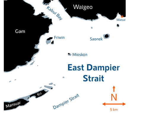
This Reef Brief covers the northeastern portion of the Dampier Strait, from the settlements of Yenbekwan on the east side of Pulau Mansuar to the regional hub of Kota Waisai on Pulau Waigeo. To instead find our coral condition report on the areas around Arborek & Sauwandarek in the northwest section of the Dampier Strait, please click here.
The Dampier Strait lies between the islands of Gam to its north & Batanta to the south, and encompasses a large array of limestone islands, cays, & patch reefs. Located at the entrance of the Indonesian Throughflow, the Dampier Strait is constantly inundated by powerful warm ocean currents from the Pacific Ocean that drive a complex web of water exchanges between its islands. This effect is especially present along the surrounding patch & fringing reefs that adorn the islands of Mansuar & Kri, situated just above the center of the flow. The result is a collection of exposed & protected coral reefs fueled and connected by deep nutrient-rich upwellings.
This combination of geology, oceanography, and temperature is responsible for the explosion of underwater diversity and life that Raja Ampat is known for, and the Dampier Strait is popularly regarded as its epicenter. Kilometer-long exposed fringing reefs dominated only by the dense Isopora brueggemanni can be found just a stone throws away from ultra diverse Acropora coral gardens in sheltered reef flats, each full of astonishing fish biomass.

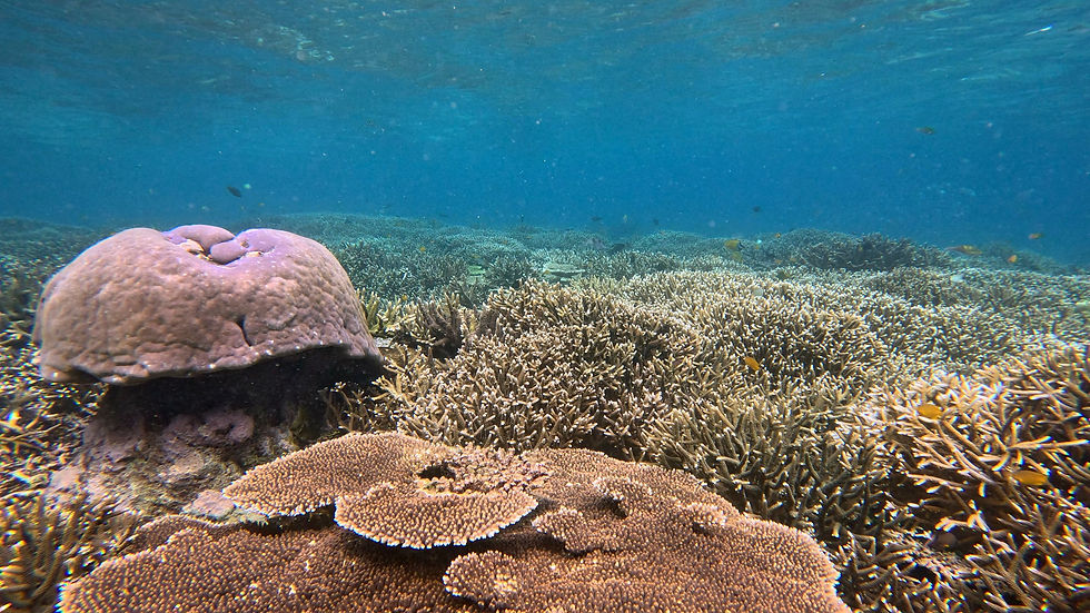
Shallow terraces carpeted in diverse arrangements of hard corals are common in the East Dampier Strait
The East Dampier Strait is unfortunately the core of tourism in Raja Ampat thanks to its misleading reputation as 'The Last Paradise'. Hordes of irresponsible tourists & operators alike feed fish, stand on corals, or crash into them during the area's difficult dives. Meanwhile, marine heatwaves continue to increase in frequency & severity due to human driven Climate Change. But worst of all, clusters of homestays line every available shore while flocks of liveaboards navigate waterways, both (directly & indirectly) releasing untreated sewage into the water column. The amount of waste released in the north portion of the Dampier Strait is estimated by some to be equivalent to a city of ~70,000 residents.
Prior to the 2020's, the effect of these factors was only noticeable in the form of limited nutrient indicator outbreaks. But in November 2024, due to a severe marine heatwave compounded by increased coral vulnerability from the sewage crisis, the Dampier Strait endured its FIRST mass bleaching event in recorded history. An area, once hailed as a spot of hope compared to reefs elsewhere in the world, underwent mass destruction it had previously been resistant to. It is no coincidence that the areas with the most homestays, particularly the East Dampier Strait, were the hardest hit.
As if that wasn't bad enough, 2025 was not a year of recovery for the hard corals here. Starting in December 2025, we witnessed a second (though thankfully much more limited) bleaching event across several sites in the East Dampier strait. With a super El Niño predicted for late 2026, I cant help but feel this area is doomed.

Marine heatwaves compounded by tourist-driven nutrient loading has made coral bleaching a frequent occurrence in the Dampier Strait, as seen with these bleaching Acropora colonies at the popular Cape Kri.
Not to be dramatic, but this was the lowest point of my entire 9 month journey through the Coral Triangle. Virtually every site was spent dwelling on the incredible diversity of hard corals here and wondering what they may have looked like before major development began in the mid-2010s (and the subsequent mass bleaching in 2024). There is certainly something special here in the Dampier strait, but it is now irrevocably tainted by the sheer number of rubble ruts, nutrient indicators, and active mortality present at every single site. Witnessing active bleaching at certain sites didn't help my mental state either...
I don't know if I would recommend prioritizing the East Dampier Strait's hard corals for diving/snorkeling and conservation/research. The area is significantly more degraded than surrounding regions of Raja Ampat that also require immediate protection, and liveaboard & homestay sewage output is still increasing with development.
Walkthroughs of the East Dampier Strait
Surveying the reefs of the East Dampier Strait was considerably easier than other areas in Raja Ampat. While environmentally devastating, the plethora of homestays new & old provided reasonable access to most sites. However the lack of dive boats, high local cost of fuel, and strong unpredictable currents significantly strained our site selection. As a result, we often chose to only snorkel target sites, though we did scuba dive four sites.
Nonetheless, we reviewed 13 sites from December 23rd to 27th for hard coral health, whose walkthroughs and data can be viewed below. Some sites may have their names, coordinates, and maps censored if the corals are deemed too vulnerable to be shared with the public.
Sites Table of Contents
Site One
December 23

The monocultures of Isopora brueggemanni that dominate Site One are composed of many phenotypes
The 500m long east-to-west fringing reef at Site One is entirely dominated by Isopora brueggemanni. The topography of the site is consistently a wide shallow reef flat, upper fore reef slope starting at ~3-4m deep and ending at 10m+ deep, and a deeper sandy slope. Coral cover in the first two zones is generally high but there are constantly rubble ruts, bleaching colonies, and nutrient indicators of varying quality. The bottommost section of coral cover is almost always destroyed or at least destabilized. Currents were strong to moderate & visibility was always high.
So... this was it. This is the 'best' site that we saw in the eastern portion of the Dampier Strait. What do I mean by 'best'? Relative to the rest of this brief, this site had the largest, most continuous stretch of not too damaged hard coral cover of all thirteen sites. While far from the most colorful or most diverse, if you're looking for 'as far as the eye can see' that isn't totally full of negative indicators, Site One is all we found. It literally, quantitatively, does not get better than this. Yikes. At least it was one of my favorite corals...
Site One Site Walkthrough
Site One Site Data
Cape Kri
December 24

Acropora colonies in the shallows of Cape Kri undergo mild coral bleaching during December 2025's marine heatwave
The famous Cape Kri dive site is the easternmost tip of the fringing reef of Pulau Kri, specifically its steep southern slope and wide ~8m deep terrace. Coral cover is only ever present in low to moderate percentages on the sandy slope, and in severely degraded conditions on the terrace & in the shallows. Active morality, bleaching, and disease are everywhere, though fish biomass is high. This site is one of, if not the most popular in the core of Raja Ampat. Currents were only moderate (though this seems to be a rare occurrence) and visibility was always high.
Because of this site's huge reputation (but lack of online hard coral pics), I was very skeptical of what this site had to offer before beginning the dive... and I was totally right. The hard corals here are in a very sorry state, and if it weren't for the wonderful feeling of vindication, it probably would have left me depressed. If this is what the beloved Cape Kri looks like after the 2024 mass bleaching... I'm scared to see the rest of the island.
Cape Kri Site Walkthrough
Cape Kri Site Data
Otdima
December 24
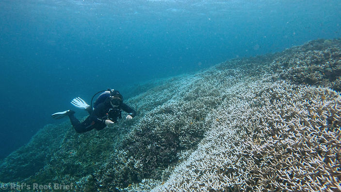
A diver glides over the rutted, bleaching Acropora colonies that blanket Otdima's shallow reef
Otdima is a well-known dive site on liveaboard itineraries over a kilometer offshore, in the channel between the islands of Mansuar & Gam. The site consists of a thin ridge-turned-patch reef about ~4m deep and surrounded by steep, rocky slopes. The reef flat is entirely dominated by branching Acropora though their condition is very dire. Almost every large colony was *at least* moderately bleaching with severe amounts of nutrient indicators present between branches or dominating ruts of rubble in the matrix. Speaking of ruts, there's a bunch of them—a major portion portion of the site's cover is gone, both from recently and from long ago. Currents were very strong & visibility was very high.
This site was a real doozy. I was not expecting the Acropora fields here to be so utterly degraded or actively bleaching—but we did get to dive the site with the local legend Oto, whom it was supposedly named after, which was a nice consolation prize. 'Oto, di mana?'... Get it? The ripping currents were also fun.
Otdima Site Walkthrough
Otdima Site Data
Friwinbonda South
December 24

Intact communities of high hard coral cover have become a rarity at Friwinbonda's southern fringing reef
The protected southern fringing reef of Pulau Friwinbonda consists of a 100m+ wide reef flat and short upper fore reef that ends above a steep sandy slope. The upper fore reef and reef flat wax and wane in percent cover, whereas the sandy slope only presents sporadic coral cover until ~20m deep. Acropora, both tabling and branching, dominates the entire reef here. A significant amount of the reef is degraded with plenty of new & old rubble alongside active bleaching, disease, & cyanobacteria.
I don't have much to say about Friwinbonda. There was some decent cover, but the amount of rubble, bleaching, and nutrient indicators killed any joy I had in seeing it. I wish I could have seen sites like this before the 2024 Mass Bleaching, I bet they were awesome.
Friwinbonda South Site Walkthrough
Friwinbonda South Site Data
Site Five
December 24, 25

Branching Acropora dominate the diverse outer reef flat at Site Five
Site Five consists of a large fringing reef that forms a corner around the north & east sides of a tall karst island. The site is defined by a large reef flat, surrounded by gradually sloping upper fore reef above sandy slopes with isolated bommies. Hard coral cover was generally moderate to low and degraded with a decent amount of disease & active bleaching, except for two areas on the outer reef flat with very intact hard coral cover. Fish presence was high, especially on the sandy slope. The area is frequented by divers and snorkelers. Currents were moderate to low and visibility fluctuated from high to low.
We both dove and snorkeled this site, and the two routes will be combined into this one walkthrough. After our previous sites, in which only one still had some big zones of undisturbed coral cover, I was very pleased with the hard corals here. Were they distressed? Yes. Were some areas recently devastated? Also yes. But I'll take what I can get!
Site Five Site Walkthrough
Site Five Site Data
Site Six
December 25

Fused tabular Acropora can reach giant sizes in the right conditions, like at Site Six's high flow back reef
Located along the south & west side of the same continuous reef & island as Site Five, Site Six consists of a very large fringing reef surrounded by semi-exposed upper fore reefs, with extensive reef flats & a shallow back reef. Hard coral cover is greatly varied with multiple long-gone rubble fields and recently devastated areas alongside intact ones with almost no damage. There was some moderate bleaching & a small COTS outbreak at the end of the site. Dominant genera & growth forms vary greatly by zone. Currents and visibility ranged between moderate to low.
Like Site Five, this site left me impressed despite the apparent mortality in certain areas. After the damage that we've witnessed on all the sites so far, I'm just grateful there are even small sections of reef left where no negative indicators can be seen within view. Plus, some of the coral assemblages here were drop dead gorgeous!
Site Six Site Walkthrough
Site Six Site Data
Site Seven
December 25

A massive Porites is buried in a sea of colorful, much faster growing Acropora on the reef crest at Site Seven
Site Seven consists of a large fringing reef around the southern corner of a tall limestone island. The eastern half of the reef before the corner consists of a very wide, gradually sloping reef flat 4-6m deep above a steep drop-off. The coral cover on the upper fore reef along the edge of the drop-off is generally very low, but does vary after turning the corner around the site. The flat here is dominated by fields of branching & tabular Acroporids, with some areas demonstrating very high cover. There was a moderate COTS outbreak at the end of the site and a notable amount of active mortality throughout. The western half of the site is similar in topography, though the reef flat is only about 1 meter deep and the slope above the drop-off is much thinner. Currents ranged from very strong to mild and visibility was always high except in the wave area towards the start. Before leaving, we snorkeled a sandy bay 500 meters away on the same fringing reef, where the coral cover was similarly variable.
Like Sites Five & Six, this one wasn't so bad! Sure, there was a COTS outbreak. And fields of rubble. And a lot of diseased colonies. BUT there were also decently large patches of undisturbed & intact hard coral cover, so compared to the sites seen on other days in this brief, I really can't complain.
Site Seven Site Walkthrough
Site Seven Site Data
Site Eight
December 25

Despite not being a true coral at all, hydrozoans (fire corals) in the genus Millepora can often be found side-by-side with hard corals in many reefs, including Site Eight
Site Eight is a shallow west-east fringing reef in a large open bay, semi-exposed to waves and currents that bring in very high fish biomass. The site generally consists of a very shallow reef crest and reef flat above a several meter deep terrace that sits atop a short sandy slope with sparse bommies. Coral cover is very diverse, with sections dominated by hydrozoans, Acropora, Montipora, Echinopora, Stylophora, and more. Live cover is usually high but there are a significant number of rubble ruts full of nutrient indicators every few meters in the matrix, as well as significant fluorescence and mild bleaching. Currents were always moderate with decent wave activity and visibility was very high until the end of the site.
Despite the wonderful pictures of the shallow diverse hard coral cover that you are about to see, this site really got me depressed. Not because it was totally destroyed or fully bleached like other locations in this brief, there wasn't enough damage to do that; instead, the site was just degraded enough to ensure that there were small rubble holes, bleaching colonies, or active mortality to taint every field of view. Site Eight is one of three snorkel locations that are highly regarded in online circles for corals, and I can't help but feel that I am witnessing it about 30% of the way on its journey of decline. The hard coral cover here is still high & diverse, but after last year, it is quite scarred, and for me that is very hard to ignore.
Site Eight Site Walkthrough
Site Eight Site Data
Kri North
December 26

Columnar Isopora palifera & fused tabular Acropora are adapted to withstand high wave energy areas like Pulau Kri's northern shore
The semi-exposed fringing reef on the north side of the famous Pulau Kri consists of a very wide, shallow reef flat above a steeply sloping upper fore reef that culminates in a sandy slope & plateau. Coral cover varies but is generally dominated by columnar Isopora and fused tabular Acropora. Both the flat & especially the upper fore reef are degraded with significant disease, nutrient indicators, recent mortality, and a minor COTS outbreak. It's no surprise then that many homestays line the sandy beach on the northern shore and that the area is busy with tourists. Currents ranged from strong to non-existent & visibility was high.
Prior to the 2024 Mass Bleaching, some reports and YouTube videos indicated that this was the stretch of highest coral cover along Kri's famous north shore. It's the second of three sites (the others being Site Eight & Site Thirteen), that were highly regarded before 2024. And save for a handful of moments, this is no longer true; there was a lot of devastation here.
Kri North Site Walkthrough
Kri North Site Data
Sorido Bay
December 26

In the sheltered back slope of Sorido Bay, Acropora colonies are able to grow into thin, tangled thickets
Sorido Bay, located inside the reef flat at the eastern end of Pulau Kri, is a partially sheltered deep lagoon stirred by strong flow over the adjacent fringing reef. The lagoon's protected western half is lined by a shallow reef flat and gradual sandy slopes featuring branching Montipora, Anacropora, and Acropora at different points. The eastern portion receives moderate wave action. The entire site is quite degraded with variable coral cover afflicted by disease, Drupella outbreaks, and cyanobacteria. There is a legacy resort on the west shore of the bay with two large jetties. Currents were strong at the start, but the west end of the bay had no currents and moderate visibility.
If it weren't for the pictures of this site that I had seen in its heyday, I don't think that I would have been that surprised by the amount of destruction here. But when comparing the two, and knowing that the luxury resort still sells the lagoon as a 'thriving reef' while likely still contributing to its degradation, it just makes my blood boil.
Sorido Bay Site Walkthrough
Sorido Bay Site Data
Kri South
December 26

The large waves and high flow at Pulau Kri's southern edge force branching Acropora to grow into short dense mounds
The south side of Pulau Kri is defined by a jagged line of tall karst cliffs above an exposed, continuous fringing reef. This reef generally consists of a very shallow low cover reef flat above a gradually sloping upper fore reef that ends above a very steep wall-like slope. Live hard coral cover is generally very low with the site dominated mostly by rubble & recently deceased colonies, though in some areas there are still decent amounts of live colonies present. Fish life was very high, especially among predators and schools of planktivores. The cliffs here prevent homestays so there is very little human activity, other than a mysterious logging operation about halfway down the reef. Currents were strong to moderate and visibility was always high except for the logging area & end of the site.
Another dip around Kri, another coral disaster. Personally, this site finally confirmed what I was previously unwilling to accept—that every corner of Kri has been damaged since the events of 2024. For almost 2 kilometers we surveyed the reef, praying it would at some point reveal a hidden refuge of healthy corals. Other than a brief Acropora field at the start, no such refuge was found. Sigh.
Kri South Site Walkthrough
Kri South Site Data
Site Twelve
December 26

The calm, semi-turbid waters at Site Twelve allow thin fragile Echinopora horrida to compete with thicker branching competitors
The protected fringing reef at Site Twelve is made up of a sloping upper fore reef & very shallow outer flat dominated by Isopora brueggemanni for the first half of the site. The second half is more diverse with large stands of Echinopora horrida on the slope and massive Porites in the deeper outer reef flat. These zones sit above a barren, sandy slope that culminates into a plateau at ~12m for the entire site. Hard coral cover varies but is generally low to moderate with large degraded rubble zones. Significant disease & Drupella outbreaks as well as some other nutrient indicators were present. Unsurprisingly, there are a handful of adjacent budget homestays & jetties. Currents were non-existent and visibility was generally moderate on the slopes but abysmal in the reef flat.
I've once stated that it's hard for me to not enjoy an I. brueggemanni dominated reef—that's still true here, sort of. The large amount of rubble at this site made it mostly meh, but I did like some of the nicer Isopora & Echinopora. At this point in our East Dampier Strait review, the plethora of mortality & disease didn't phase me.
Site Twelve Site Walkthrough
Site Twelve Site Data
Yenbuba to Cape Mansuar
December 27

The small but intact matrix of Acropora at Cape Mansuar's high flow terrace attracts large numbers of schooling fish who seek shelter within its branches
The continuous fringing reef around Cape Mansuar and up to the ever popular Yenbuba jetty can be split into two sections. The first is the sheltered reef flat and short slope that start at the jetty and continue to the cape, which is one of the busier snorkel/dive sites in central Raja Ampat. A number of tourists can be seen feeding fish and steeping on the reef every day here, and this stretch is generally made up of devastated foliose coral rubble. The second section is the exposed 1.5km long fringing reef that runs west along the cape's cliffs. This section is equally low cover, though its rubble fields are deeper and look much older, sometimes coated in coral-killing sponge & soft corals. Despite the low coral cover, fish biomass was high. Currents were strong only at the cape's tip and visibility was usually high except at the latter half of the second section.
This site just sucks from a coral perspective—but hey, that's the perspective you read these briefs for, right? Irresponsible tourists, completely obliterated zones of reef, and entire carpets of nutrient indicators. Of course, there were still a lot of big fish and the few patches of hard corals left intact were wonderful, but this stretch used to be touted online as the third of the three best coral gardens in the core of the strait. How far it has fallen... quite possibly the worst (but most fitting) way to end our time examining the severely degraded hard corals of the East Dampier Strait.
Yenbuba to Cape Mansuar Site Walkthrough
Yenbuba to Cape Mansuar Site Data
How to Visit the Corals of the Eastern Dampier Strait
Like with many of the locations on this website, and in Indonesia in particular, visiting the hard corals of Raja Ampat is quite the challenge. The usual woes of getting to the region, planning one's logistics, bringing the right gear, and having the in-water skills required are tough here. Finding sustainable dive & snorkel operators who will accompany you to the specific sites & depths with the highest coral cover can be even harder.
Lets focus in on that last sentence— sustainable. It's no secret that the dive & snorkel travel industries (and to a lesser extant, all travel in general) have an undeniable negative impact on hard coral environments. This is especially applicable in Raja Ampat, where largely unrestricted tourism has caused near-irreversible harm via sewage, mechanical damage, and development.
Absolutely no one who isn't contributing to the conservation of these reefs in a significant way should be visiting if their visit are causing measurable harm to the integrity of the ecosystem present. This is something I take very seriously which will be reflected in the recommendations below. If sustainable means are not present, this section will be unavailable indefinitely.

Oops... We're still working on
the guide for this location!
Receive a notification & be the first to read this guide once published. Plus, get access weekly coral insights.
Site Index — Quick Access
DISCLAIMER: This blog post does not constitute scholarly research, nor is it partnered with or associated with any scientific research, institutions, journals, publications, or scholars. All observations are qualitative and informal, observed during standard recreational activities without accordance with scientific norms, methods, accreditation, training, or procedures. These observations are presented only as blog posts intended for environmental enthusiasts on Rafsreefbrief.com. All blogs and observations are not submitted to nor meant for use by any scientific publications or purposes, and are not meant to support any scientific truth, conclusion, profit, or technology. Observations are only valid at time of occurrence. All opinions expressed are our own. We are not liable for any damages or losses resulting from the use ore reliance of information contained on Rafsreefbrief.com or its media accounts. Seriously people, this is just an environmental-travel hobby & blog, nothing more!